

I remember the first time I stumbled onto those windswept bluffs—lungs burning, boots muddy, and utterly lost. That was fifteen years ago. Since then, I’ve returned to this misty wilderness more times than I can count, mapping its secrets through seasonal shifts and personal milestones.
Point Reyes isn’t just a place I hike. It’s become my reset button, my wilderness therapist, my cathedral of cypress and fog.
Contents
- 0.1 WHERE LAND SURRENDERS TO SEA
- 0.2 WHAT NOBODY TELLS YOU ABOUT POINT REYES
- 0.3 THE SOUL-SHAKING TRAILS YOU SHOULDN’T MISS
- 0.4 TOMALES POINT: WHERE ELK ROAM THE EDGE OF EVERYTHING
- 0.5 ABBOTTS LAGOON: THE PERFECT INTRODUCTION
- 0.6 CHIMNEY ROCK: DRAMA IN CONCENTRATED FORM
- 1 SEASONAL SECRETS: WHEN TO GO AND WHY
- 2 BRING THE RIGHT GEAR OR SUFFER THE CONSEQUENCES
- 3 SECRET SPOTS THE RANGERS DON’T MENTION
- 4 WILDLIFE ENCOUNTERS THAT CHANGED ME
- 5 PRACTICAL MATTERS FOR PLANNING YOUR ESCAPE
- 6 FINAL THOUGHTS: WHY I KEEP RETURNING
WHERE LAND SURRENDERS TO SEA
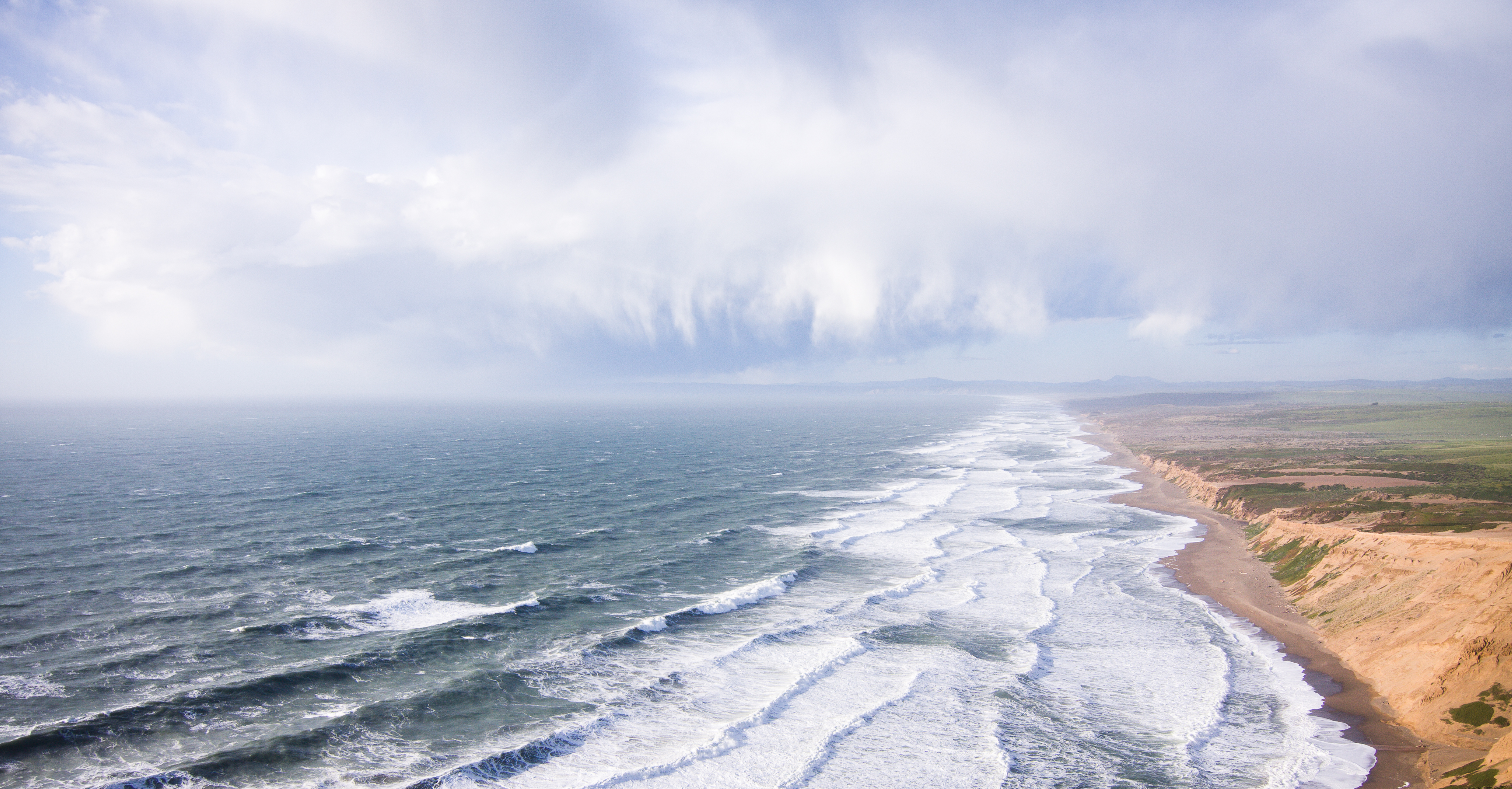
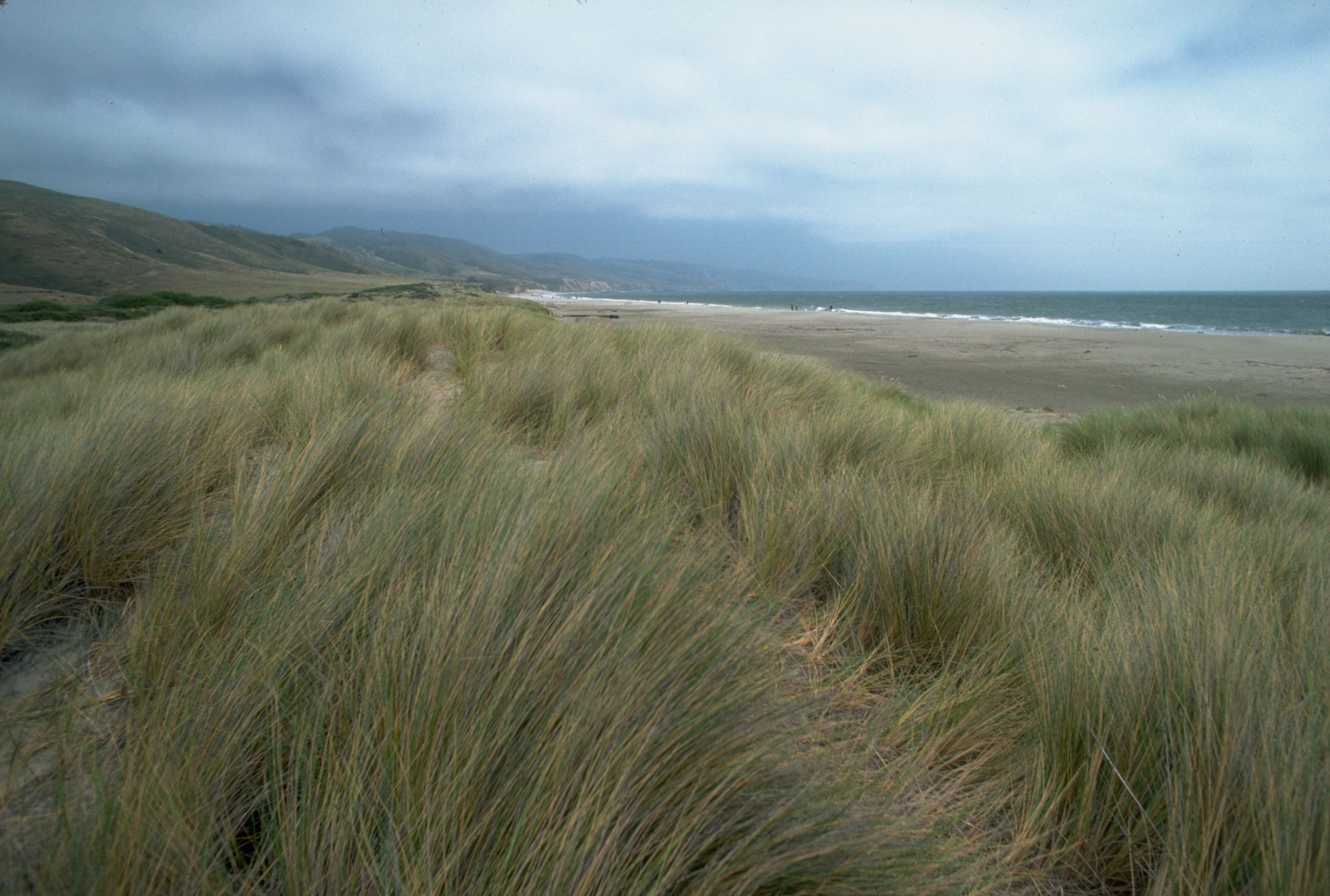
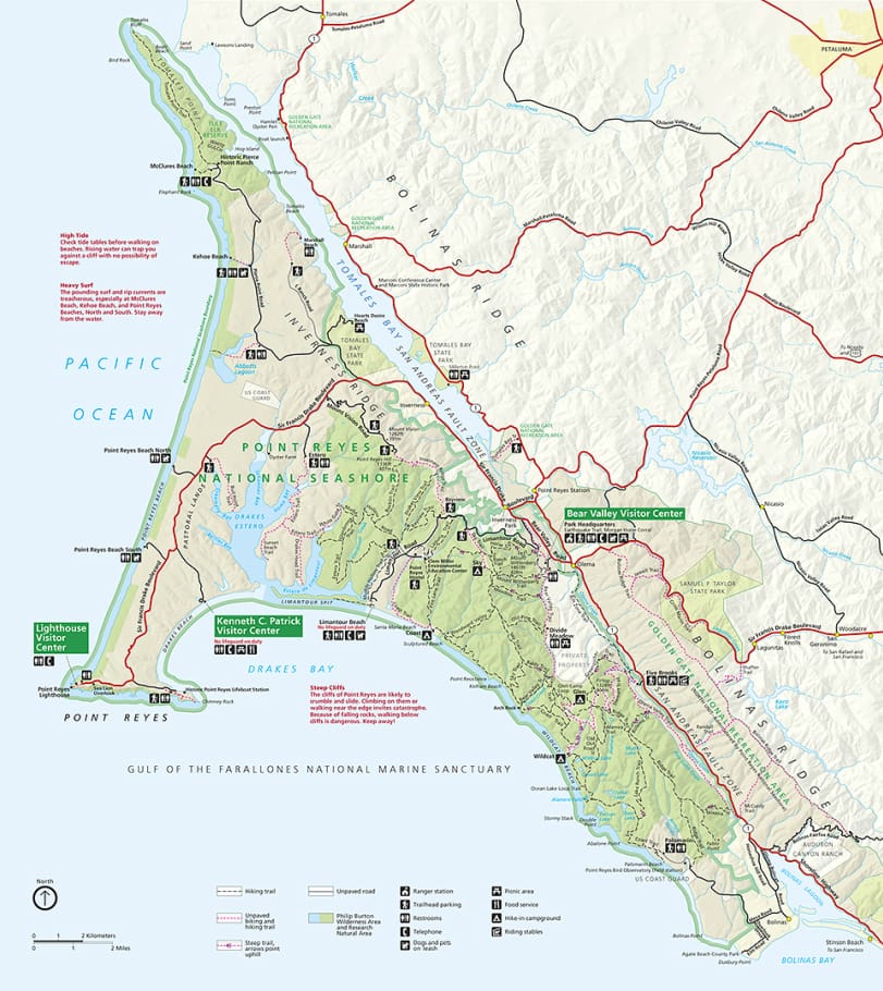
Northern California keeps its finest jewel hidden beneath a perpetual veil of coastal mist. Point Reyes National Seashore dangles like a wild, crooked finger into the Pacific—a 70,000-acre peninsula where ecosystems collide and nature writes poetry in sand, rock, and tide.
Most guidebooks tell you there are 150 miles of trails here. They’re lying. There are 150 miles of official trails. But spend enough time wandering these coastal bluffs and forest hollows, and you’ll discover countless unnamed deer paths and local shortcuts that don’t appear on any map.
That’s the thing about Point Reyes—it rewards the repeat visitor. The faithful. The obsessive who returns despite soaked boots and fog-blinded vistas.
Some days deliver cathedral-like silence in ancient bishop pine groves. Others bring horizontal rain that turns your fancy Gore-Tex into an expensive sponge. Both experiences are perfect in their own way.
WHAT NOBODY TELLS YOU ABOUT POINT REYES
Let’s get this out of the way: the weather here will betray you. Pack for four seasons regardless of the forecast. I once started a July hike in tank top weather only to end it huddled under my emergency blanket as fog reduced visibility to ten feet and temperatures dropped twenty degrees.
The locals have a saying: “Don’t like the weather at Point Reyes? Wait fifteen minutes.” They’re not entirely joking.
Second truth: cell service is virtually non-existent once you leave the Bear Valley Visitor Center. Your Instagram stories will have to wait. Your navigation app will fail you. Bring a paper map and know how to use it, or risk joining the ranks of disoriented hikers who’ve spent unplanned nights listening to coyotes serenade the darkness.
Third confession: Some trails don’t play nice. The Estero Trail becomes a boot-sucking mud fest after rain. The Sky Trail’s exposed sections transform into wind tunnels during winter storms. And that picturesque Alamere Falls? The “shortcut” trail has caused more ankle injuries and ranger rescues than any path has a right to claim.
I say this not to discourage you, but to prepare you. Because when you witness fog filtering through ancient cypress branches like ethereal fingers, or spot a bobcat slinking through coastal scrub at dawn, you’ll understand why these challenges are merely the price of admission to paradise.
THE SOUL-SHAKING TRAILS YOU SHOULDN’T MISS
TOMALES POINT: WHERE ELK ROAM THE EDGE OF EVERYTHING

This 9.5-mile out-and-back hike traces a narrowing spit of land where tule elk rule and three horizons of endless blue surround you. I’ve hiked this trail two dozen times and never once had the same experience.
My most vivid memory? Watching a late September rut where massive bull elk with velvet-shedding antlers battle for mating rights, their haunting bugle calls echoing across the peninsula. The primal sound raises goosebumps even now, years later.
The trail itself starts innocently enough at the historic Pierce Point Ranch, where abandoned white buildings stand testament to the dairy industry that once dominated these hills. From there, it’s a gradual climb through coastal prairie where coyote brush and lupine frame ever-expanding ocean views.
What nobody warns you about is the final mile, where the trail narrows dramatically and drops away on both sides, creating a vertiginous ridge walk to the very tip of the peninsula. On clear days, you can see all the way to Bodega Bay. During summer fog, you might barely glimpse your own boots.
Pro tip from a veteran: The last two miles offer zero shade and no water. That refreshing-looking pond near mile three? Seasonal and sometimes toxic with algae. Pack twice the water you think you need.
ABBOTTS LAGOON: THE PERFECT INTRODUCTION

When friends visit for the first time, I always take them here. This gentle 3-mile round-trip walks the line between accessible and wild, between manicured and raw.
The first section crosses a freshwater marsh on a well-maintained trail where red-winged blackbirds perform aerial acrobatics and chorus frogs provide the soundtrack. Then comes the brackish middle lagoon, where river otters occasionally make appearances if you’re quiet and patient.
But the real payoff comes when you crest the final dune and the vast Pacific suddenly appears—a blue eternity framed by miles of untouched beach in both directions. It’s the kind of moment that stops conversations mid-sentence.
I’ve built driftwood shelters here during winter winds, watched harbor seals bob offshore in spring swells, and once, on a lucky April morning, spotted a migrating gray whale and calf so close to shore I could hear their exhalations.
The beach section isn’t technically part of the trail, but ignore it at your peril. Head north along the sand and you’ll eventually reach sculptural driftwood formations that would make Andy Goldsworthy jealous. Go south and you might spot snowy plovers, those tiny endangered shorebirds that nest directly in the sand.
CHIMNEY ROCK: DRAMA IN CONCENTRATED FORM

When time is short but your need for wild beauty is high, Chimney Rock delivers. This 1.8-mile lollipop loop packs more punch per step than perhaps any trail in California.
The path traces an exposed peninsula where wildflowers explode in spring displays that border on psychedelic. I once counted seventeen different varieties in bloom during a single April hike—California poppies creating rivers of orange among purple lupine and yellow goldfields.
But the stars of this show are the elephant seals that haul out on the protected beaches below the cliffs from December through March. During peak pupping season, the beaches transform into a blubbery battlefield of 5,000-pound males battling for territory while females nurse their young. The sound—a combination of bellows, grunts, and what can only be described as wet raspberry noises—carries up to the trail and provides a bizarre soundtrack to your hike.
The historic lifeboat station at the trailhead is worth exploring, too. Rangers sometimes open this restored 1927 building where crews once launched rescue boats into treacherous waters. The maritime history here runs deep—over fifty shipwrecks line the nearby coast, earning Point Reyes the ominous nickname “Graveyard of the Pacific.”
SEASONAL SECRETS: WHEN TO GO AND WHY
Point Reyes defies the conventional California calendar. Forget everything you know about summer being the prime season. Here, nature flips the script.
WINTER: THE UNEXPECTED PRIME TIME (DECEMBER-FEBRUARY)
While most hikers hibernate, winter transforms Point Reyes into something extraordinary. Storms scrub the air to crystal clarity between downpours. Waterfalls that remain parched much of the year suddenly roar to life. The 680-foot Alamere Falls becomes a thundering spectacle after heavy rains, cascading directly onto the beach in a rare “tidefall” formation.
This is also prime whale-watching season. Gray whales migrate past these headlands between December and April, often visible from Chimney Rock and the lighthouse area. I once counted seventeen spouts during a single hour’s watch from the Lighthouse overlook.
Winter brings another gift: solitude. Trails that suffer summer crowds return to their wild state. I’ve hiked ten miles on the Coast Trail in January without encountering another soul.
The downside? Rain transforms some clay-based trails into slick challenges. Alamere Falls becomes practically inaccessible after heavy storms when Coast Trail creek crossings flood. Check with rangers before attempting any ambitious winter routes.
SPRING: WILDFLOWER EXPLOSIONS (MARCH-MAY)
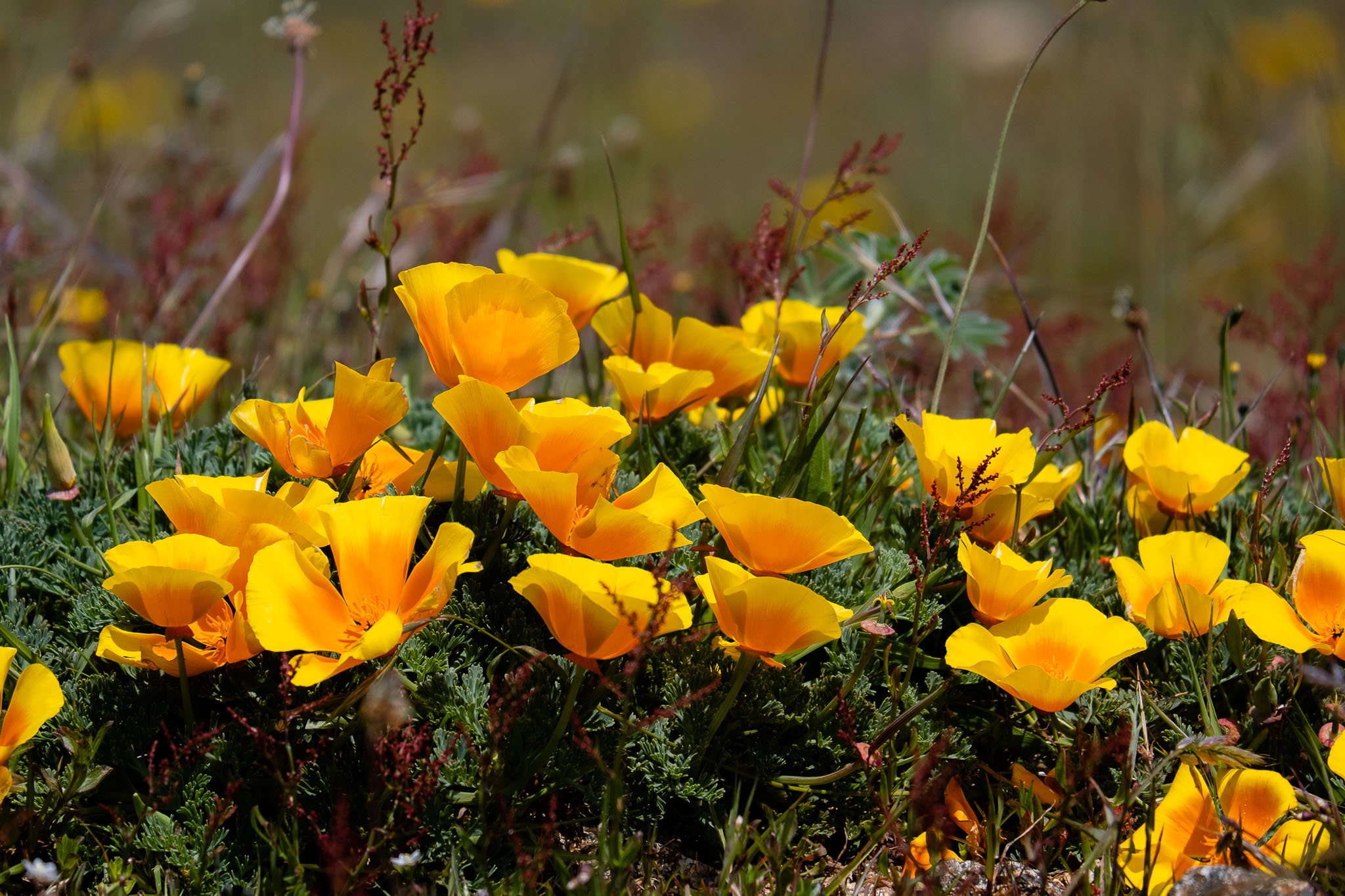
If there’s a perfect season here, it might be spring. Hillsides draped in emerald velvet erupt with wildflower displays that seem almost artificial in their intensity. Douglas irises create purple rivers through forest understory. California poppies transform coastal bluffs into orange carpets. The air itself feels pregnant with possibility.
Weather stabilizes somewhat, though morning fog remains common. Temperatures hover in the 50s and 60s—ideal for vigorous hiking without overheating. By May, most trails have dried enough for comfortable passage, yet waterfalls still flow with winter’s lingering bounty.
Spring also brings new life. Harbor seal pups appear on protected beaches. Tule elk calves wobble alongside their mothers. Bird migration peaks, transforming Abbotts Lagoon into an avian Grand Central Station.
One April dawn, I watched a coyote hunting gophers in a field so thick with spring wildflowers that only her ears and occasional pouncing movements were visible above the blooms. These are the moments that burn themselves into memory.
SUMMER: THE SEASON OF FOG (JUNE-AUGUST)

Here’s the truth outsiders rarely grasp: summer is Point Reyes’ most challenging season. While inland California bakes, coastal fog transforms these headlands into a mystical, moisture-laden world.
Mark Twain never actually said, “The coldest winter I ever spent was a summer in San Francisco,” but whoever did coin that phrase could have been talking about Point Reyes. Temperatures rarely exceed the 60s, and fog can reduce visibility to mere feet for days on end. I’ve hiked entire trails seeing nothing but gray mist and immediate surroundings, only to have the fog dramatically part for three minutes of breathtaking panorama before closing in again.
The fog creates its own magic, though. Coastal forests drip with condensation, turning ordinary spider webs into jeweled masterpieces. The muffled quiet creates an intimate atmosphere where distant foghorns provide the only soundtrack. And when the fog does temporarily lift, the resulting light quality turns ordinary landscapes into luminous paintings.
Summer does offer one major benefit: predictably dry trails. Creek crossings that require careful navigation in winter become simple rock-hops. Mud-prone sections harden into manageable paths.
FALL: THE LOCALS’ SECRET (SEPTEMBER-NOVEMBER)
Ask any Point Reyes regular about their favorite season, and many will whisper “fall” with a secretive smile. September and October often deliver the peninsula’s clearest, warmest days as summer fog patterns retreat. Crowds thin dramatically after Labor Day, returning these wild spaces to their natural quiet.
Fall brings the tule elk rut, when massive bulls battle for mating rights at Tomales Point. Their eerie bugling echoes across the peninsula—an ancient sound that raises the hair on your neck. Migrating birds stop over on their southern journeys, creating seasonal hotspots for birdwatching at wetland areas.
The landscape color palette shifts subtly. Coastal grasses turn golden, creating a warm contrast with the ever-blue Pacific. Poison oak announces itself with brilliant scarlet leaves (beautiful but not to be touched). Mushrooms begin appearing in shadowed forest corners after the first rains.
I’ve found October mornings particularly magical—when overnight dew creates gossamer brilliance on every spider web, and the slanting autumn light turns ordinary scenes into photographer’s dreams.
BRING THE RIGHT GEAR OR SUFFER THE CONSEQUENCES
My first serious Point Reyes hike taught me an expensive lesson in preparation. Three miles into a planned eight-mile loop, skies that had been merely overcast transformed into a sideways downpour. My cotton sweatshirt became a sodden weight. My canvas sneakers squelched with every step. And the temperature, which had started in the comfortable 60s—plummeted into the mid-40s as wind whipped off the ocean.
I’ve become an evangelist for proper gear ever since. Here’s what actually works:
THE LAYER SYSTEM THAT SAVED MY ADVENTURES
Forget whatever clothing strategy works elsewhere in California. Point Reyes demands a specialized approach:
- Base layer: Synthetic or wool (NEVER cotton). Moisture-wicking long sleeves save lives here.
- Insulating layer: Fleece or lightweight down. Even summer days can turn brisk when fog rolls in.
- Wind/rain shell: Non-negotiable. The peninsula creates its own weather systems, and conditions change with zero warning.
- Hiking pants: Quick-dry materials only. Convertible options with zip-off legs give flexibility for those rare hot afternoons.
- Hat with brim: Sun protection when clear, rain protection when not.
- Gloves: Yes, even in summer. Morning temperatures in the 40s aren’t uncommon.
I stash a waterproof stuff sack with extra warm layers at the bottom of my pack year-round. Better to carry it unnecessarily for months than need it once and not have it.
FOOTWEAR THAT FEARS NO TERRAIN
Trail conditions here range from hard-packed fire roads to ankle-deep mud bogs, often on the same hike. After experimenting with every option:
- Mid-height waterproof hiking boots with aggressive tread patterns work best for mixed conditions
- Gaiters aren’t overkill during the rainy season (November-March)
- Quick-dry trail runners make good summer alternatives when the trails firm up
THE EXTRAS THAT MAKE THE DIFFERENCE
- Trekking poles: Essential for steep sections like Sky Trail and mud navigation during rainy season
- Navigation: Paper map AND compass (don’t rely on cell service for digital maps)
- Headlamp: Even for day hikes—fog can make 4pm look like dusk
- Extra food: Energy demands increase in cool, damp conditions
- Extra water: Many trails have zero water sources, and those seasonal streams on your map? Often dry.
The Bear Valley Visitor Center sells decent maps, but invest in the National Geographic Trails Illustrated version for more detail and durability. Tom Killion’s phenomenal woodblock prints of Point Reyes landscapes make outstanding souvenirs that capture the area’s spirit better than any photograph.
SECRET SPOTS THE RANGERS DON’T MENTION
After hundreds of visits, I’ve developed a mental map of special places that rarely make the official guides. Share these wisely.
THE CYPRESS TUNNEL AT SUNSET
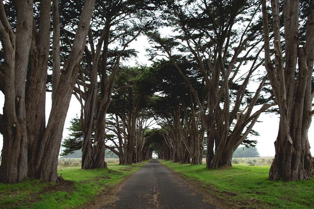
This row of ancient cypress trees lining the road to the historic RCA radio station creates a living tunnel that frames the setting sun perfectly at certain times of year. Photographers line up for this shot during the summer solstice, but visit in November for equally spectacular light with no crowds.
To find it, follow Sir Francis Drake Boulevard past the turnoff for Chimney Rock, continuing until you see the unmistakable cypress archway on your right.
THE GHOST FOREST OF INVERNESS RIDGE
Few visitors know that a devastating fire swept across Mount Vision in 1995, burning 12,000 acres of forest. The burn zone has regenerated remarkably, but certain areas along Sky Trail still feature hauntingly beautiful “ghost forests” where bleached trunks of bishop pines stand sentinel among their young successors.
The contrast between charred remnants and vibrant new growth creates a landscape that feels almost sacred in its cycle of destruction and renewal. Visit on a foggy morning when mist wraps around these pale pillars for an otherworldly experience.
THE SECRET SHELL BEACH ACCESS
Most visitors to Limantour Beach head straight from the parking lot to the main beach. Instead, turn right at the sand and walk approximately half a mile along the beach. Look for a small, unmarked trail heading right into what appears to be impenetrable brush. This overgrown path leads to a hidden cove where shells accumulate in quantities rarely seen on more visited beaches.
Time your visit for negative low tides in spring, when the receding waters reveal tide pools teeming with ochre sea stars, purple urchins, and the occasional octopus.
WILDLIFE ENCOUNTERS THAT CHANGED ME
Point Reyes hosts over 45% of North American bird species and dozens of land and marine mammals. But encountering them requires patience, timing, and occasionally, luck.
THE TULE ELK RUT: NATURE’S GLADIATORIAL SPECTACLE
Each September, Tomales Point transforms into an evolutionary battlefield as bull elk with massive antlers battle for breeding rights. Their haunting bugle calls—somewhere between a whistle, roar, and otherworldly scream—echo across the peninsula.
One unforgettable dawn, I watched two magnificent bulls, each weighing nearly 800 pounds, charge each other repeatedly, antlers clashing with sounds like axe blows on hardwood. Steam rose from their bodies in the cool morning air as they pushed and twisted, neither willing to surrender. The cows grazed nearby, seemingly indifferent to this dramatic competition for their attention.
To witness this primal display, hike at least two miles out on the Tomales Point Trail during September or early October. Morning and evening offer the most active periods. Bring powerful binoculars—rangers enforce safe distances during rutting season when bulls become unpredictable.
ELEPHANT SEALS: EVOLUTION’S STRANGEST EXPERIMENT
The protected coves below Chimney Rock host one of nature’s most remarkable spectacles from December through March. Male elephant seals—some weighing over 5,000 pounds with distinctive trunk-like proboscises—establish breeding territories through brutal battles that sometimes draw blood.
Meanwhile, females give birth to black-furred pups that double their weight in just weeks on extraordinarily rich milk. The beach becomes a continuous cacophony of bellows, roars, and the strange gurgling vocalizations unique to this species.
Park docents often set up spotting scopes at the Elephant Seal Overlook, but serious wildlife enthusiasts should bring their own optics. The minimum viewing distance is about 300 feet, so a spotting scope or camera with a telephoto lens enhances the experience substantially.
THE GREAT WHITES BELOW
Few visitors realize that the waters off Point Reyes host one of the Pacific’s highest concentrations of great white sharks. These aren’t the man-eaters of movie fame but sophisticated predators specializing in marine mammals.
While chances of spotting them from shore are slim, their presence becomes apparent during pupping season when harbor seals cluster defensively in protected coves rather than spreading along open beaches. Elephant seals bear dramatic scars from encounters, and park biologists occasionally document predation events.
Marine biologist Scot Anderson, who has studied these sharks for decades, once told me: “The waters between Point Reyes and the Farallon Islands are essentially the dining room for the Northeast Pacific white shark population.” This hidden reality adds another layer to the wild nature of these shores.
PRACTICAL MATTERS FOR PLANNING YOUR ESCAPE
GETTING THERE AND GETTING AROUND
Point Reyes sits approximately one hour north of San Francisco, but don’t let the short distance fool you. The winding roads demand caution, particularly in fog or rain. From San Francisco, take Highway 101 North to the Sir Francis Drake Boulevard exit in Larkspur, then follow it west until it meets Highway 1 in Olema. Alternative routes include Highway 1 northbound along the coast—slower but spectacularly scenic.
Public transportation exists but requires planning. Weekday buses run from San Rafael Transit Center to Point Reyes Station, but reaching trailheads from town often requires additional shuttles or taxi services.
Vehicle access reaches most major trailheads, though unpaved Pierce Point Road can become challenging during heavy rains. The Bear Valley Visitor Center offers the most parking capacity and serves as the hub for park information.
WHERE TO SLEEP BETWEEN ADVENTURES
Accommodations within the National Seashore are limited to four hike-in campgrounds: Coast, Glen, Sky, and Wildcat. Each offers a distinctive experience:
- Coast Camp: Ocean views, beach access, and minimal shelter from elements
- Glen Camp: Forested setting with better wind protection
- Sky Camp: Panoramic vistas from exposed ridge locations
- Wildcat Camp: The most remote, with stunning coastal access
All require reservations through recreation.gov, often months in advance for summer weekends. Each site includes a food storage locker (essential for raccoon defense), picnic table, and access to pit toilets. Only Wildcat offers reliable year-round water; others require carrying all you’ll need.
For those preferring solid walls, the gateway communities offer options ranging from basic motels to luxury bed-and-breakfasts:
- Point Reyes Station: The central hub with the most services
- Olema: Small cluster of inns at the park’s southern entrance
- Inverness: Quieter waterfront setting along Tomales Bay
My personal recommendation: HI Point Reyes Hostel offers private rooms and dormitory beds in a former ranch house near Limantour Beach. It’s the only lodging option actually within park boundaries besides camping.
SEASONAL CAUTIONS AND CONSIDERATIONS
- Rainy Season (November-March): Trails can become impassable after heavy storms. Alamere Falls Trail often closes due to dangerous creek crossings. Check trail conditions at the visitor center before setting out.
- Fire Season (June-October): Occasionally results in trail closures or even park shutdowns during extreme conditions. The 1995 Mount Vision Fire and 2020 Woodward Fire both significantly impacted the park.
- Breeding Seasons: Harbor seal pupping (March-June) closes certain beaches. Snowy plover nesting (March-September) restricts some dune areas.
- Poison Oak: Ubiquitous year-round. Learn to identify this three-leafed menace (“leaves of three, let it be”) and stay on established trails.
LOCAL KNOWLEDGE THAT MAKES THE DIFFERENCE
- Time your coastal hikes for low tide when possible. Beach access points like Sculptured Beach become impassable at high tide.
- The park’s microclimates mean temperatures can vary 20+ degrees between Bear Valley and the outer coast, often within a three-mile hike.
- Weekdays offer dramatically fewer crowds, particularly Tuesday through Thursday.
- Cell service disappears quickly once you leave developed areas. Download maps and inform someone of your hiking plans.
FINAL THOUGHTS: WHY I KEEP RETURNING
Point Reyes isn’t just a collection of spectacular trails—it’s a living laboratory where nature’s processes unfold largely unhindered by human intervention. The scientific term is “ecological integrity,” but what you’ll feel is something more visceral: a sense of witnessing something authentic and timeless.
I’ve marked personal milestones on these trails: brought new loves here for their first real wilderness experience, processed grief along wind-battered bluffs, celebrated achievements with sunset beach fires (in designated areas only!), and found clarity during periods of confusion.
The peninsula asks something of its visitors—flexibility, preparation, respect. It doesn’t offer the predictable experiences of more developed parks. Some days deliver horizontal rain instead of spectacular views. But those who approach with openness find rewards beyond scenery: a reminder of our place within natural systems larger than ourselves.
As writer Philip L. Fradkin noted in his book about the region: “Point Reyes is a landscape of subtlety rather than grandeur, of mist rather than crystal clarity, of complex ecological processes rather than simple vistas.”
I keep returning because each visit peels back another layer of this complexity. The more I learn, the more I realize how little I truly know about this wild edge where land meets sea. And in an increasingly programmed world, that mystery feels like the rarest resource of all.